
Working Endurance |  | All Constellation Signal Tracking | | | Tilt Survey 60° |
| | | ||||||
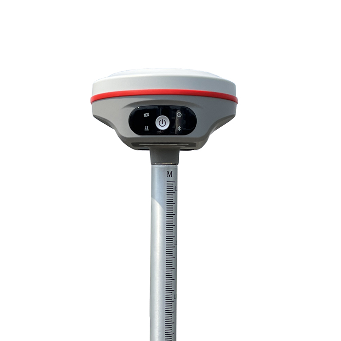
| Powerful GNSS Chip | 8-15 km Radio Range | Barrier-Free Measurement | ||||||
| New generation of powerful GNSS mainboard K803 with 1598 channels enables K2 to support a wide range of satellite signals, including GPS, GLONASS, BeiDou,Galileo, QZSS, SBAS, etc, as well as Galileo HAS and BDS PPP. | K2 has an built-in transceiver radio, the frequency can be figured from 410 to 470 Mhz. The typical working range of theradio is 8-15km. Farlink Pro protocol is available in 2025. | Built-in 7.4V 6800mAh high-capacity battery, the battery life is more than 15 hours in rover mode. one charge, meets all-day work. The battery cell can be recharged with long life, the performance is more secure and reliable. | ||||||
| | | ||||||
| WiFi and Web UI | IMU Tilt Survey | Linux OS | ||||||
| By connecting through the integrated WiFi of K2, you can logon an user-friendly management platform on the browser of your phone or computer. All status monitoring and parameter settings can be achieved in a fast and easyway. | Built-in lMU compensator, correct the coordinates according to the tilt direction and angle of the centering rod automatically within 60°, assist you quickly and accurately survey or stake out points without leveling the pole. It improves working efficiency by 20-30%. | Powered by the new generation of embedded Linux operating system, K2 has a greatly improved RTK performance and efficiency. A unique core processing mechanism is able to response to more than one command at each time. |
| Satellite Tracking Ability | ||
Channels1598 channels | Constellation GPS, GLONASS, BEIDOU, GALILEO, QZSS, SBAS | L-BandBDS PPP & Galileo HAS |
| Positioning Output Rate1-20 HZ | Initialization Time2-8 s | |
| Positioning Precision | ||
UHF RTKHorizontal ±8mm +1 ppm | Network RTKHorizontal ±8mm +0.5 ppm Vertical ±15mm +0.5 ppm | |
| Static and Fast-Static Horizontal ±2.5mm +0.5 ppm | RTK Initial time 2-8s | |
| User Interaction | ||
Operation SystemLinux | Screen DisplayNot Available | wifi & 4GYes |
Voice Guideyes, 8 language | Data Storage4 GB internal | Web UIYes |
| Keypad1 physical button | ||
| Working Capability | ||
RadioBuilt-in transmitting and receiving (Farlink & Farlink Pro) | Tilt Survey Inertial Measurement | Electronic BubbleYes |
| Endurance up to 15 hours (Rover mode) | OTG (Field Download) yes | |
See more specs
6635
KOLIDA K2 EN 250625.pdf
PDF [11.299MB] download
KOLIDA Instrument (KOLIDA) is a leading manufacturer of precision surveying equipment.
COMPANY PROFILE


9~G17E)`TJYQF15")