
2cm/ 60° Tilt Survey Technology |  | All Constellation Signal Tracking | | | 10 New Programs |
 | The World Leading GNSS Engine The Maxwell 7 GNSS engine inside K1 PRO provides an ultra-fast positioning speed, typically it starts tracking satellite signal within 5 seconds after turning on, coordinate can be acquired within 10 seconds. |
Star-Fill, Save the Signal Loss This new function will let you to continue working a few minutes when radio or mobile signal is becoming very poor or even lose in blind area. The accuracy is down to 2cm. See the video from https://youtu.be/VvHJN6bkUDo |  |
 | Star-Link, Infinite Freedom 2cm accuracy Star-Link correction service is available! After subscribing to it, surveyors can work almost anywhere in the world without a base station or VRS network. Ideal solution for surveying and mapping, natural resource exploration in remote area. (The photo left is a Kolida user who uses Star-Link to work in original forest in Sabah State, Malaysia, without base station and CORS network. Instrument model K5 infinity, photo time is late 2019) |
10 Innovations to Increase Efficiency More than 10 programs or functions were re-designed to make your work flow simpler and smoother, let you to work easier and comfortable, help you to get more reliable working result. Search "K1 Pro Kolida" on youtube.com to discover it. |  |
 | More Durable and Rugged K1 PRO is fully sealed, has a IP 68 level proof. The built-in battery has 10,000 mAh capacity and can work 8 to 14 hours as RTK rover, with only one recharge. External battery case SA6003 can add 13,600 mAh and provide extra a few working hours. (SA6003 is an optional accessory) video: http://youtube.com/watch?v=7YYwvT0ULbA |
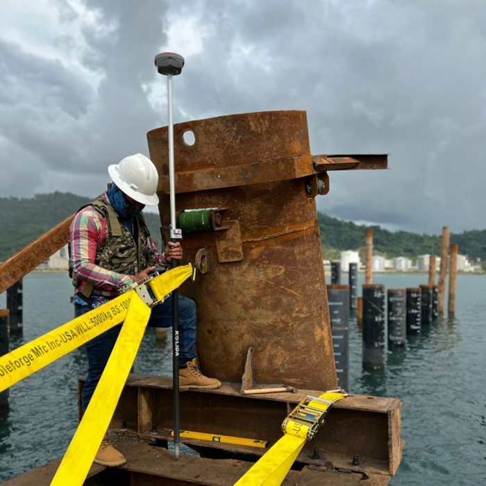
Work Safer and Easier Thanks to the inertial measurement technology, K1 PRO allows user to do a tilt survey with a maximum tilt angle of 60 °. Centering is not a must, so surveyors can stay in safe position when they measure on motorway, and don't need to step into water . |  |
 | Fast and accurate Not like tilt sensor, Inertial Measurement Unit is no more affected by the earth's magnetic field and requires no correction. It can be activated and start working within only few seconds, this fast positioning will increase measurement speed by over 30%. The combination algorithm of IMU + GNSS can get fixed solution faster and keep measurement results more stable, accuracy is down to 2cm. |
Measure where others can't Corner of wall? Points underneath pipe? Points occupied by car? These targets are no more accessible.. |  |
| Long Range Radio Link SDL400 built-in radio can send signal as far as 7 km in urban area, 8 km in suburban. The maximum coverage is up to 200 sq.km, suitable to have multiple rovers work simultaneously. Watch video at youtube.com: https://youtu.be/7YYwvT0ULbA |
Barrier-Free Measurement In difficult environment you may lost connection with base station or VRS network. Don't be disappointed, you can choose from 3 creative work modes to continue surveying without interruption. (Repeater/ Router/ Mobile Refenrence Station) |  |
 | Anti-interference SDL400 built-in radio features anti-interference capability, so K1 PRO can work close to power plant, transformer substation, mobile signal tower and other interference source. |
Practical Functions K1 PRO employs Linux system, it helps surveyors to accomplish their missions easier, faster and more accurate by delivering exceptional quality and innovative features. |  |
|
|
New app. New Productivity Windows CE data controller is too old technology? No problem. Simply download SurvX App on your smart phone or tablet. Enjoy the smooth operation of Android platform ! | Post-processing Sw. Free of Charge KOLIDA GEO Office integrates static data processing & Kinematic data adjustment |
Video Demonstration: https://www.linkedin.com/pulse/2020-new-model-k1-k20s-series-increase-your-efficiency-andy-lau/ | |
| Satellite Tracking Ability | ||
Channels672 channels | Constellation GPS, GLONASS, BEIDOU, GALILEO, SBAS, QZSS | MMS L-BandStar-Fill (default), Star-Link (optional) |
| Positioning Output Rate1-50 HZ | Initialization Time<10s | |
| Positioning Precision | ||
UHF RTKHorizontal ±8mm +1 ppm | Network RTKHorizontal ±8mm +0.5 ppm Vertical ±15mm +0.5 ppm | Star-Link by L-bandHorizontal ±2cm Vertical ±5cm |
| Static and Fast-Static Horizontal ±2.5mm +0.5 ppm | RTK Initial time 2-8s | |
| User Interaction | ||
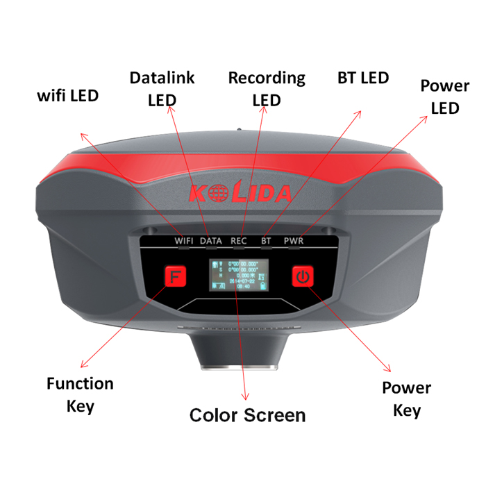
Operation SystemLinux | Screen Display1 inch LCD | wifiYes |
Voice Guideyes, 8 language | Data Storage8 GB internal, 32GB external | Web UIYes |
| Keypad2 physical buttons | ||
| Working Capability | ||
RadioBuilt-in emitting and receiving, typical working range 1-8 km | Tilt Survey Inertial Measurement | Electronic BubbleYes |
| Endurance >14 hours (static mode), >7 hours (internal UHF base mode), 8 to 14 hours (rover mode) | OTG (Field Download) yes | Other Function Mobile reference station, Repeater, Router |
| Satellite Tracking Ability | ||
Channels672 channels | Constellation GPS, GLONASS, BEIDOU, GALILEO, SBAS, QZSS | MMS L-BandStar-Fill (default), Star-Link (optional) |
| Positioning Output Rate1-50 HZ | Initialization Time<10s | |
| Positioning Precision | ||
UHF RTKHorizontal ±8mm +1 ppm | Network RTKHorizontal ±8mm +0.5 ppm Vertical ±15mm +0.5 ppm | Star-Link by L-bandHorizontal ±2cm Vertical ±5cm |
| Static and Fast-Static Horizontal ±2.5mm +0.5 ppm | RTK Initial time 2-8s | |
| User Interaction | ||
Operation SystemLinux | Screen Display1 inch LCD | wifiYes |
Voice Guideyes, 8 language | Data Storage8 GB internal, 32GB external | Web UIYes |
| Keypad2 physical buttons | ||
| Working Capability | ||
RadioBuilt-in emitting and receiving, typical working range 1-8 km | Tilt Survey Inertial Measurement | Electronic BubbleYes |
| Endurance >14 hours (static mode), >7 hours (internal UHF base mode), 8 to 14 hours (rover mode) | OTG (Field Download) yes | Other Function Mobile reference station, Repeater, Router |
See more specs
15311
K1 PRO ES 20200429.pdf
PDF [10.339MB] downloadK1 Pro FR 20200917.pdf
PDF [2.715MB] downloadK1 PRO-672 20-11-25.pdf
PDF [10.35MB] download
KOLIDA Instrument (KOLIDA) is a leading manufacturer of precision surveying equipment.
COMPANY PROFILE

