
All Constellations Signal Tracking |  | | | standard industrial level |
 | KOLIDA NET S9 has a 336 channels integrated professional GNSS board, compatible with all constellations. (965 channels optional) |
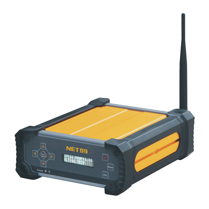
In addition, we greatly improve the operation experience and convenience for users with the additional function of WiFi hotspot and Bluetooth connections, thus, users are able to configure receiver with any mobile terminal. NET S9 is not only able to record STH file, but also support RINEX file storage. |  |
 | 10000mAh high capacity of battery built-in, can act as a primary power source or as an Uninterupted Power Supply (UPS) backup.KOLIDA NET S9 is using eMMC (Embeded Multi Media Card) technology for internal memory, faster and larger, stable and reliable. Moreover, NET S9 allows to connect to an external storage devices(maximum up to 1TB) via USB Host interface so that you don't have to worry about data storage. |
The KOLIDA CR-3 UHG provides a stable phase center offsets at sub-millimeter level to guarantee your reference station an excellent tracking performance. Choke rings design inside the antenna helps achieve an outstanding multipath rejection performance. High-gain design for low elevation tracking enhances signal availability for more satellites. Ultralow line loss on signal transmissions, enables connecting cable extend more than 100 meters carrying undamaged signals. Fully sealed core components, waterproof and dustproof design, make it withstand severe conditions for continuous work in the field. |  |
| GNSS | ||
Channels 336 channels (965 Optional) | GPSL1 C/A, L2E, L2C, L5 | GLONASS L1 C/A, L1P, L2 C/A(GLONASS M only), L2P |
BDSB1, B2, B3 | GALILEOL1 BOC,E5A,E5B,E5AItBOC1 | SBASL1, L2C, L5 |
| InitializationTypically<10 seconds | Initialization reliability>99.9% | |
| Accuracy | ||
Accuracy Code differential GNSS positioning Horizontal: 25mm+1ppm RMS Vertical: 50mm+1ppm RMS | SBAS positioning accuracy<5m (typically) 3DRMS RMS | Static GNSS surveying Baseline<30km Horizontal: 2.5mm+0.1ppm RMS Vertical: 3.5mm+0.4ppm RMS |
Static GNSS surveying Baseline>30km Horizontal: 4mm+0.5ppm RMS Vertical: 9mm+0.5ppm RMS | Real-time Kinematic Baseline<30km Horizontal: 10mm+1ppm RMS Vertical: 20mm·+1ppm RMS | Real-time Kinematic Network RTK Horizontal: 8mm+0.5ppm RMS Vertical: 15mm+0.5ppm RMS |
| Data storage & output | ||
Data storage8G (extend to 32G) internal memory is capable of cycle-recording raw data, adopts eMMC technology, stable and reliable | Positioning rate1Hz, 2Hz, 5Hz, 10Hz, 20Hz, 50Hz(depend on setup option) | Reference output CMR, CMR+, RTCM2.1, RTCM2.2, RTCM2.3, RTCM3.0, RTCM3.1, RTCM3.2, sCMRx, RTCA, NOVATELX |
Navigation output ASCII: NMEA-0183 GSV, AVR, RMC, HDT, VGK, ROT, GGK, GGA, GSA, ZDA, VTG, GST, PJT, PJK, BPQ, GLL, GRS, GBS and binary | Data format Support STH, RINEX2.x, RINEX3.x raw data storage | Data retrievalDownload form HTTP, FTP Push and USB copy |
| Data communication | ||
Ethernet protocolSupport TCP/IP, HTTP and NTRIP protocol | Serial port Navigation data, static data and differential correction data transmission, PPS-UTC | BluetoothBluetooth 2.1 (Class2)+EDR, 2.4GHz |
| WiFi 2.4GHz, IEEE 802.11 b/g/n, allows to access built-in web user interface with the mobile terminal via its WIFI hotspot | ||
| Electrical | ||
Power supply 9V~28V DC input, 3 separate interfaces for power supply with over-voltage protection | Battery10000mAh high capacity of battery built-in | Battery lifeMore than 15 hours for continuous work in default configuration |
Consumption Low power consumption 3.8W | ||
| User interface | ||
Front panelFront panel display with buttons and LED screen | Network interfaceTwo RJ45 network interface | RS-232 serialOne RS-232 serial port(9-pin), data transmission |
USBTwo USB port, USB host and USB device | Power interfaceThree separate power interface | Multi-function interfaceOne port supports PPS output, Event marker input, serial port and power supply |
External frequency portOne external frequency scale port, supports high-precision atomic clock connection | GPS Antenna interfaceChoke ring antenna connection | WIFI antenna interfaceAllows to connect a WIFI broadcast antenna |
| Physical | ||
Dimension(L×W×H)216mm×178mm×72mm | Weight2.28kg | Shock and vibrationRugged aluminum alloy housing plus plastic ring seal, designed to survive a 2m drop onto concrete |
Waterproof/DustproofIP67 level standard, protect against for temporary immersion to a depth of 1m; Completely protect from dust | ||
| Environmental | ||
Storage temperature-40℃~+80℃ | Working temperature -40℃~+75℃ | HumidityRelative humidity, 10%-100%condensing |
See more specs
3969
Net S9 Kolida 990 202009.pdf
PDF [1.617MB] download
KOLIDA Instrument (KOLIDA) is a leading manufacturer of precision surveying equipment.
COMPANY PROFILE